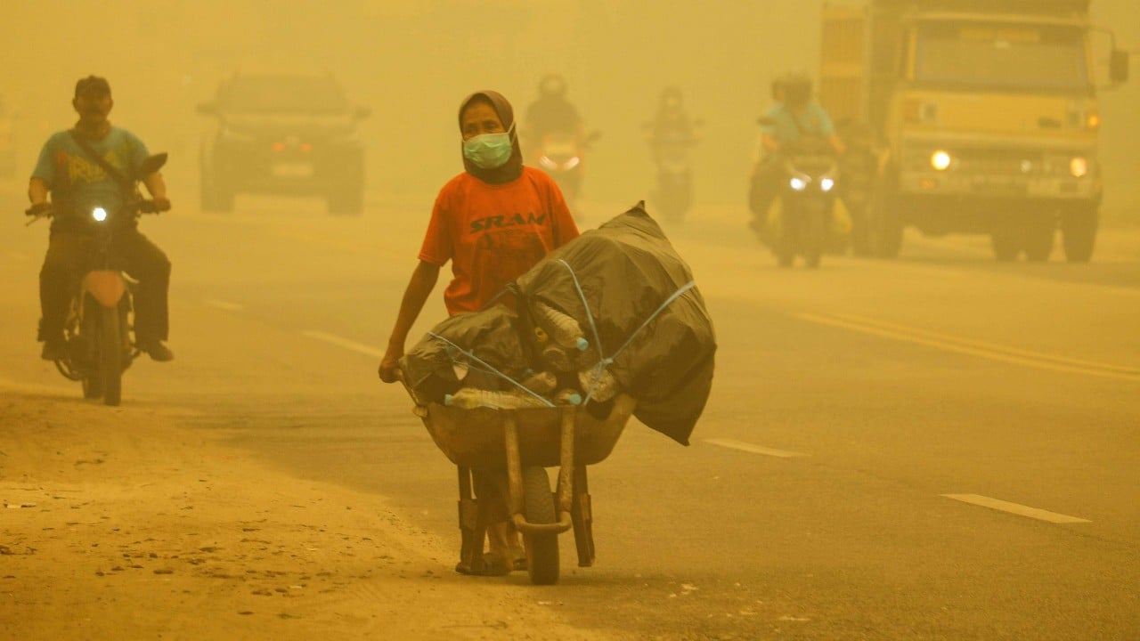
You smell it before you see it.
It starts as a faint, phantom sweetness, like someone burning wet autumn leaves three neighborhoods over, until the back of your throat begins to itch and the morning sun turns the color of a bruised tangerine. In Singapore, the skyline doesn't disappear all at once during a bad haze event; it erodes, building by building, glass tower by steel frame, swallowed by a thick, yellowish-grey curtain that drifts silently across the Singapore Strait from the peatlands of Sumatra and Kalimantan.
For decades, that curtain has been more than a meteorological nuisance. It has been a recurring geopolitical fever. Every dry season, as the southwest monsoon shifts, millions of people across Southeast Asia find themselves checking air quality apps the way others check the weather, trading outdoor runs for air purifiers, and watching their governments engage in a familiar, exhausting dance of finger-pointing and diplomatic friction.
Recently, Singapore and Indonesia announced a step designed to break that cycle: the creation of a dedicated bilateral haze task force and a renewed commitment to sharing critical environmental data. On paper, in the dry language of diplomatic communiqués, it sounds like routine bureaucratic housekeeping. A committee here, a dataset there.
It isn't. When you strip away the diplomatic phrasing, this agreement is an admission that the old ways of fighting transboundary haze—public shaming, defensive denials, and siloed monitoring—have failed the people actually breathing the air.
The Invisible Anatomy of a Crisis
To understand why sharing a spreadsheet of coordinates can spark a diplomatic crisis, you have to understand what is actually burning.
Picture a hypothetical small-scale farmer named Pak Hendra in Riau province, Sumatra. Let's be clear: Pak Hendra is a composite character, drawn from the realities documented across rural Indonesia, not a specific individual. For him, land is survival. Clearing scrub and secondary forest with fire—slash-and-burn agriculture—costs a fraction of hiring heavy machinery. When the dry season hits, a match is the cheapest tool in his shed.
Now zoom out. Multiply Pak Hendra by thousands, and add massive industrial palm oil and pulpwood concessions operating on drained peatlands.
Peat is not ordinary dirt. Think of a healthy tropical peatland as a colossal, waterlogged sponge made of partially decayed plants accumulated over thousands of years. Left alone, it locks away staggering amounts of carbon. When companies or farmers dig drainage canals to dry out the land for planting, that sponge turns into a subterranean fuel depot. Once a fire catches on the surface, it burrows downward, smoldering underground for weeks or months, impervious to ordinary rain, pumping out a toxic cocktail of carbon monoxide, ammonia, cyanide, and fine particulate matter known as PM2.5.
Those microscopic particles—thirty times smaller than the width of a human hair—are the real villains. They bypass the body's natural defenses, slipping deep into the lungs and entering the bloodstream.
Now shift fifty kilometers across the water to Jurong West in Singapore. Imagine a mother—we will call her Mei Lin, another hypothetical composite representing thousands of families—waking up at 3:00 AM to the sound of her six-year-old son wheezing. The Pollutant Standards Index (PSI) on her phone has climbed past 200, well into the "Very Unhealthy" range. She tapes wet towels along the gaps under her front door, seals the window frames with masking tape, and cranks up an air purifier whose replacement filters sold out across the island two days ago.
Mei Lin doesn't care about jurisdictional boundaries or concession maps. She cares that her child is struggling to breathe. Meanwhile, Pak Hendra doesn't see a skyline disappearing across the sea; he sees a family to feed in an economy that offers few affordable alternatives to fire.
Between those two realities sits a massive wall of politics, pride, and legal ambiguity.
Why Data Became a Diplomatic Weapon
If satellites can spot a hotspot the size of a living room from orbit, why has stopping the haze been so agonizingly difficult?
The answer lies in the gap between seeing a fire and proving who owns the ground beneath it.
For years, Singapore’s National Environment Agency and international watchdogs have used NASA and other satellite feeds to track thermal anomalies across Sumatra and Kalimantan. You can see the red dots blooming on a map in near real-time. You can even watch the wind plumes carry the smoke straight toward the Malay Peninsula.
But a satellite image is just a picture of heat. To prosecute a company, levy a fine, or revoke a license, authorities need concession maps—the exact legal boundaries showing which corporation, cooperative, or smallholder holds the rights to that specific patch of burning peat.
And in Indonesia, land tenure has historically been a labyrinth. Overlapping claims, outdated paper registries, local district permits that conflicted with national ministry maps, and fierce debates over corporate secrecy turned concession data into a geopolitical third rail.
The tension boiled over visibly during the catastrophic haze crisis of 2015, one of the worst in recorded history. Peat fires burned across roughly 2.6 million hectares of Indonesian land—an area larger than the entire state of Massachusetts. The World Bank estimated the disaster cost Indonesia alone $16.1 billion, more than double the cost of rebuilding Aceh after the 2004 tsunami. Across the region, schools shuttered, flights were grounded, and Harvard and Columbia researchers later estimated that the smoke contributed to over 100,000 premature deaths across Indonesia, Malaysia, and Singapore.
In the aftermath, Singapore leaned into its Transboundary Haze Pollution Act, a landmark piece of legislation allowing the city-state to fine local or foreign companies responsible for haze affecting Singapore, even if those companies had no physical presence on the island. Singaporean authorities issued legal notices to several Indonesian firms.
Jakarta pushed back hard. To many Indonesian officials, the moves felt like an infringement on national sovereignty—a wealthy neighbor lecturing a developing giant while Singapore-listed banks and companies profited from the very palm oil supply chains driving deforestation. Indonesia froze certain environmental cooperation agreements and insisted that concession maps were state secrets, arguing that releasing them publicly could expose the government to lawsuits or violate domestic confidentiality laws.
The stalemate was paralyzing. Singapore had advanced atmospheric modeling and satellite analysis capabilities; Indonesia had ground truth, local jurisdiction, and the legal authority to put out the fires and punish the culprits. Yet distrust kept those tools locked in separate rooms.
Living Inside the Grey
If you have never lived through a severe Southeast Asian haze episode, it is hard to convey how profoundly it alters the texture of daily life. It isn't like a thunderstorm that blows through and leaves the air crisp, or a winter blizzard you can bundle up against. It is an inescapable, claustrophobic weight.
I remember walking through central Singapore during one of the severe spikes—the air so thick that the Marina Bay Sands towers looked like faint pencil sketches drawn on tracing paper. People walked briskly with N95 masks strapped tight over their faces, their eyes stinging, conversations muffled behind layers of polypropylene fabric. The city's famous hawker centers, usually deafening with the clatter of woks and chatter, felt subdued, half-empty. Even inside air-conditioned malls, the smell lingered in the stairwells and elevator shafts, a sharp, acrid reminder that the boundary between indoors and outdoors is mostly an illusion.
There is a particular kind of psychological exhaustion that sets in when the air itself turns hostile. You lose the simple, unthinking freedom of opening a window. Parents watch their children grow restless indoors day after day. Elderly residents with heart or respiratory conditions become prisoners in their own flats. Outdoor workers—construction crews, delivery riders, street sweepers—have no choice but to keep moving through the smog, inhaling particulates with every heavy breath.
And beneath the physical discomfort runs a quiet current of frustration. You feel powerless. You cannot recycle your way out of transboundary haze. You cannot buy an electric car and make the smoke vanish. Your health is tethered to decisions made in boardrooms and rural districts hundreds of miles away, filtered through the fragile mechanics of international diplomacy.
The Shift From Blame to Architecture
That shared vulnerability is precisely why the newly announced bilateral haze task force matters—and why its design signals a meaningful shift in strategy.
Consider what happens when two neighbors stop arguing over who started the fire and start building a shared fire alarm.
Over the past several years, Indonesia has made genuine, measurable strides on the ground. Following the trauma of 2015, Jakarta established the Peatland and Mangrove Restoration Agency, enforced a permanent moratorium on new primary forest and peatland clearing, deployed rapid-response fire brigades, and began the massive undertaking of "One Map" policy—an effort to reconcile conflicting land-use registries into a single, authoritative geospatial database. Hotspots dropped significantly between 2020 and 2022, helped in part by wetter La Niña weather patterns, though dry El Niño years quickly reminded everyone how fragile those gains remain.
Yet dry seasons always return. Climate change is making droughts sharper and peatlands drier. Relying on good weather is not a strategy.
By forming a joint task force and establishing formal channels to share data, Singapore and Indonesia are attempting to institutionalize cooperation so it doesn't collapse the moment the wind shifts. Instead of waiting until smoke blankets Changi Airport—when public anger forces politicians into defensive postures—the task force creates a standing mechanism for technical teams to talk before the dry season peaks.
Think of it like a shared cardiovascular monitor between two intertwined bodies. Data sharing in this context means pooling meteorological forecasts, hotspot detections, soil moisture readings, and ground-level verification. When Singapore’s satellites detect a thermal anomaly in a high-risk peat zone, technical counterparts in Indonesia can cross-reference that coordinate against their internal registries immediately, dispatching local teams to douse a smoldering patch before it turns into an uncontrollable underground inferno.
Crucially, keeping this data exchange within a structured, government-to-government task force bypasses the sovereignty trap that doomed previous efforts. Indonesia retains control over its domestic legal processes and sensitive corporate registries, while Singapore gets assurance that actionable intelligence is actually reaching the people with boots on the ground.
The Questions Nobody Likes Asking
Still, healthy skepticism is warranted. Southeast Asia is littered with well-intentioned environmental frameworks—most notably the ASEAN Agreement on Transboundary Haze Pollution, which took twelve years just to get ratified by every member state. Why should a new task force succeed where grand regional treaties have stumbled?
The honest answer is that it might not, unless it confronts three uncomfortable realities.
First, data without enforcement is just better documentation of a tragedy. Knowing exactly which concession is burning means very little if the company holding that permit faces fines that amount to a minor operating expense, or if local officials look the other way during election cycles. The task force will only earn public trust when shared data visibly translates into extinguished fires and revoked licenses.
Second, the economic roots of fire are stubborn. Large corporations have the capital to adopt zero-burning land-clearing methods, and many major palm oil conglomerates have cleaned up their act under pressure from global supply-chain audits. Smallholders, however, remain caught in a bind. Expecting a cash-strapped farmer to rent an excavator instead of lighting a match—without providing subsidized equipment, agricultural extension training, or alternative livelihoods—is a recipe for noncompliance.
Third, supply chains do not respect borders either. Singapore is not merely a passive victim downwind of the smoke; it is a major financial and trading hub where many regional agribusinesses are headquartered, financed, or listed. True partnership requires Singapore to continue policing the financial and corporate side of the equation at home just as vigorously as it asks Indonesia to police the peatlands abroad.
It is confusing, messy, and deeply uncertain work. Nobody can promise that the skies over the Malacca Strait will stay blue every August and September.
What hangs in the balance
When diplomats shake hands over a new task force, the cameras capture crisp suits, flags, and polite smiles. Those images feel worlds away from a smoldering trench in Riau or a sealed bedroom in Jurong West.
Yet the bridge between them is direct. Every dataset shared early, every canal re-wetted to keep ancient peat damp, every hotspot caught while it is still small enough to be stomped out by a local brigade translates directly into an asthma attack that never happens, a school day that isn't canceled, a breath taken without hesitation.
The smoke has never cared about lines drawn on a map. For the first time in a long time, the people trying to stop it are starting to act the same way.
Look out a window in Singapore or Pekanbaru on a clear morning after rain, when the air is washed clean and you can see all the way to the horizon—ships lined up like dark beads on silver water, clouds stacking white and tall against a sharp blue sky. You realize how easily we take the simple, invisible miracle of clean air for granted, right up until the horizon disappears.