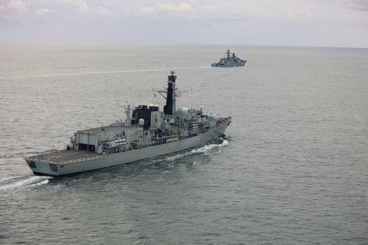
Strategic Intent and Signaling Mechanics
Surface transit by foreign warships through international waters adjacent to sovereign EEZs (Exclusive Economic Zones) serves as a primary vehicle for political signaling, maritime domain awareness testing, and operational readiness verification. When a Russian warship executes live-firing maneuvers or transit drills off the UK coastline, the event is rarely a tactical prelude to kinetic confrontation. Instead, it operates as a calculated deployment designed to test response latencies, force availability, and target-tracking continuity across NATO’s Northern Flank.
[Operational Trigger: Warship Enters Contiguous/EEZ Zone]
        │
        ├──► 1. Intelligence Gathering (EMCON Analysis & Radar Mapping)
        │
        ├──► 2. Response Latency Audit (P-8A Poseidon & Escort Intercept Time)
        │
        └──► 3. Strategic Messaging (Power Projection & Strategic Ambiguity)
Naval power projection in narrow maritime corridors—such as the English Channel and the North Sea—relies on three operational vectors: Read more on a similar subject: this related article.
- Electronic Signature Mapping: Forcing coastal defense networks to active tracking modes reveals land-based and sea-based sensor frequencies, radar emission patterns, and command-and-control (C2) nodes.
- Reaction-Time Audits: Measuring the exact delta between radar contact detection and the physical interception by host-nation surface escorts or maritime patrol aircraft (MPA).
- Strategic Distraction: Diverting high-readiness naval assets from broader anti-submarine warfare (ASW) screening tasks in the GIUK (Greenland-Iceland-UK) gap to localized monitoring missions.
Understanding these deployments requires deconstructing the physical limits of maritime transit under the United Nations Convention on the Law of the Sea (UNCLOS), the tactical constraints of surface combatants in restricted waters, and the counter-surveillance architecture deployed by host nations.
Maritime Law and the Constraints of Innocent Passage
Media coverage frequently conflates transit through an Exclusive Economic Zone with a violation of sovereign airspace or territorial waters. International law establishes explicit boundaries that govern naval behavior, operational latitude, and host-nation rights. More analysis by NPR delves into comparable perspectives on this issue.
Boundary Definitions and Jurisdictional Thresholds
- Territorial Waters (0 to 12 Nautical Miles): Absolute sovereignty applies. Foreign warships retain the right of innocent passage, defined strictly as continuous and expeditious transit. Under Article 19 of UNCLOS, passage ceases to be innocent if the vessel engages in weapons practice, intelligence gathering, acts of pollution, or any threat or use of force against the coastal state.
- Contiguous Zone (12 to 24 Nautical Miles): Host nations exercise limited jurisdiction to prevent and punish infringements of customs, fiscal, immigration, or sanitary laws.
- Exclusive Economic Zone (24 to 200 Nautical Miles): High seas freedoms apply regarding navigation and overflight. Coastal states maintain exclusive rights to economic resources, submarine cables, and marine research, but cannot legally restrict innocent transit or military drills conducted outside territorial waters, provided those drills do not pose an immediate environmental hazard or kinetic threat to coastal infrastructure.
When live-firing exercises are announced, maritime doctrine dictates the issuance of a NOTAM (Notice to Airmen) and a NAVAREA navigational warning. These warnings establish a designated Danger Area in international waters to prevent civilian collision or collateral damage. Issuing these notices fulfills legal obligations under international maritime law, preventing the coastal state from legally blocking the maneuver without escalating to a blockade scenario.
The Operational Mechanics of Coastal Interception
Monitoring and escorting foreign surface assets through sea lines of communication (SLOCs) involves a multi-domain surveillance apparatus. The operational lifecycle of an intercept spans several distinct phases.
Phase 1: Early Warning and Sensor Handoff
Long-range sea-sky surveillance networks initiate tracking long before a surface vessel approaches coastal choke points. Acoustic arrays, coastal radar arrays, and space-based Synthetic Aperture Radar (SAR) pass telemetry to localized command centers.
The primary airborne asset for this phase is the Boeing P-8A Poseidon. Operating at high altitudes, the aircraft utilizes its AN/APY-10 multi-mission maritime search radar to maintain persistent track files, while dropped sonobuoys monitor submerged escorts that often shadow surface combatants.
Phase 2: Tactical Intercept and Shadowing
Once a warship enters the operational area of interest, the host navy deploys a surface combatant—typically a Type 23 frigate or Type 45 destroyer—to establish visual and electronic contact.
+------------------+     Acoustic/Radar Track      +--------------------+
| Space/SOSUS Sensor| ---------------------------> | Coastal Joint Ops  |
+------------------+                               +--------------------+
                                                             │
                                                             ▼ Dispatch Escort
+------------------+      Visual/EMCON Track       +--------------------+
|  Type 23/45 Asset| <--------------------------- |  P-8A Poseidon MPA |
+------------------+                               +--------------------+
The escorting vessel maintains a visual shadow position, typically positioned on the quarter of the target vessel. This positioning provides three tactical advantages:
- Unobstructed Line-of-Sight: Preserves passive optical and infrared tracking without crossing the target's bow.
- Radar Shadowing: Optimizes the escort's radar cross-section relative to the target, allowing precise tracking of fire-control emissions.
- Navigation Control: Ensures the host nation asset can maneuver rapidly to block sudden course deviations toward territorial waters.
Phase 3: Emission Control and Intelligence Collection
During live-firing drills or weapons testing in international waters, passive intelligence gathering becomes the primary operational objective for both sides. The escort vessel deploys passive electronic support measures (ESM) to record:
- Radar Emission Parameters: Target tracking frequencies, pulse repetition frequencies (PRF), and pulse widths.
- Fire-Control Lock Signatures: Specific frequency shifts indicating that a weapon system has shifted from search mode to target tracking.
- Acoustic Signatures: Engine, propeller, and auxiliary machinery sound profiles recorded via towed-array sonar systems.
Structural Asymmetries in Maritime Escort Operations
Executing continuous monitoring and shadowing operations imposes disproportionate operational costs on host-nation naval forces. This dynamic creates a structural asymmetry between the transiting state and the monitoring state.
Resource Depreciation and Hull-Life Consumption
Deploying a multi-billion-dollar surface combatant to shadow a transiting vessel consumes finite hull-life hours, fuel, and maintenance cycles. For small or medium-sized navies with limited surface fleet numbers, high-frequency shadow deployments generate significant operational friction:
- Maintenance Backlogs: Unscheduled deployments disrupt planned dry-dock maintenance windows, compounding long-term fleet readiness decay.
- Personnel Fatigue: Sustained high-readiness shadowing cycles deplete crew rest allocations, reducing tactical efficiency during planned NATO exercises.
- Opportunity Costs: Escort frigates assigned to channel monitoring are unavailable for anti-submarine screening in deep-water transit zones or deployment to carrier strike groups.
Information Asymmetry
The transiting vessel controls the operational timeline. By altering its transit speed, staging sudden maneuvers, or scheduling unannounced live-fire drills within legal international zones, the transiting fleet forces the host navy to respond dynamically. The host nation must maintain maximum readiness at all times, whereas the transiting asset operates on a predetermined schedule optimized for its own crew readiness and logistics.
Tactical Risk Management in Narrow Waterways
The presence of armed combatants executing weapons drills near heavily trafficked maritime corridors introduces specific operational risks that require rigorous mitigation strategies.
Managing Collision and Miscalculation Risks
The English Channel is one of the world's busiest shipping lanes, handling hundreds of commercial vessel transits daily. Operating naval combatants within these lanes demands strict adherence to the International Regulations for Preventing Collisions at Sea (COLREGs). However, military maneuvers introduce key operational variables:
┌─────────────────────────────────────────────────────────────────┐
│                    Navigational Hazard Matrix                   │
├───────────────────────────────┬─────────────────────────────────┤
│ Commercial Traffic Density    │ High risk of sudden maneuvering  │
├───────────────────────────────┼─────────────────────────────────┤
│ Weapons Live-Fire Danger Zone │ Restricted commercial transit   │
├───────────────────────────────┼─────────────────────────────────┤
│ EMCON Interference            │ Potential GPS/AIS spoofing      │
└───────────────────────────────┴─────────────────────────────────┘
When a foreign warship conducts live-fire drills, the risk profile shifts from standard navigation to kinetic safety management. The host nation's coastal authority must ensure that merchant shipping remains clear of the designated NAVAREA danger box while maintaining continuous radar tracking to verify that fired ordnance stays within designated boundaries.
Electronic Warfare and Signal Contamination
Live-firing exercises often coincide with localized electronic warfare (EW) activity. GPS spoofing, AIS (Automatic Identification System) manipulation, and radar jamming are frequently deployed to obscure exact force compositions or to test the resilience of regional civilian and military navigation networks. Coastal operations centers must filter out synthetic or altered signal data using multi-sensor correlation—cross-referencing visual optics, satellite imagery, and passive radio-frequency direction finding to maintain a true operational picture.
Strategic Action Framework for Maritime Defense
To mitigate the resource drain and operational friction caused by persistent foreign naval transits, coastal states must transition from purely reactive surface shadowing to a tiered, asset-optimized surveillance framework.
- Shift Primary Tracking to Unmanned Aerial and Surface Systems: Relying on manned Type 23 or Type 45 platforms for long-duration shadowing burns critical surface fleet capability. Deploying medium-altitude long-endurance (MALE) uncrewed aerial vehicles (UAVs) equipped with maritime search radar reduces operational costs per flight hour while preserving surface combatant availability for primary combat missions.
- Automate Electronic Intelligence Harvesting: Deploy fixed and mobile passive RF sensor arrays along coastal high points to capture radar emissions automatically during foreign transits. This eliminates the need to move a surface ship close enough to intercept low-power radar signals.
- Optimize Multi-National Sensor Sharing Frameworks: Integrate real-time radar and acoustic feed networks across adjacent NATO allies (e.g., France, the Netherlands, Belgium) to establish a seamless handoff process. A unified track-sharing database reduces duplicate operational deployments, allowing adjacent nations to share escort duties sequentially rather than redundantly.
- Enforce Strict Counter-Signaling Protocols: Maintain strict radio silence and passive EMCON protocols on host escort vessels during intercepts. Denying transiting warships the opportunity to map host-nation fire-control or modern search radar emissions neutralizes the primary intelligence-gathering objective of the transit.