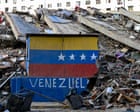
The ground in northern Venezuela didn't just shake on June 24; it completely gave way. Within mere minutes, back-to-back twin earthquakes measuring magnitudes of 7.2 and 7.5 ripped through the Caribbean coastline, centered heavily around the state of La Guaira. It's the most violent seismic activity the nation has endured in over a hundred years.
If you look at the official state television channels, the political narrative paints a controlled, albeit tragic picture. National Assembly President Jorge Rodríguez announced that 855 buildings sustained damage, counting 189 total collapses. But anyone tracking this disaster knows that number doesn't match the reality on the ground. It isn't even close.
Space agencies and independent researchers are exposing a massive data gap. By analyzing high-resolution radar imagery from the European Space Agency's Sentinel-1 satellites, Corey Scher and Jamon Van Den Hoek of Oregon State University dropped a bombshell assessment through NASA. Their findings show that approximately 58,870 buildings were likely damaged or destroyed. That is a staggering 70 times higher than the architectural casualties admitted by local officials.
When a discrepancy is that vast, it changes everything. It changes how much aid is needed, how many rescue teams are required, and how we measure the human toll of this nightmare.
The Satellite Radar Data Reaveals What the Eye Can't See
You might wonder how a satellite orbiting miles above the Earth can beat a ground-level government headcount. The secret lies in a technology called Synthetic Aperture Radar. Unlike standard photography, which can be blocked by heavy clouds or the thick smoke rising from ruptured gas lines, radar punches straight through. It maps the literal texture of the earth's surface.
When the Oregon State University team compared data from the day after the quakes to baseline imagery, they found abrupt, catastrophic surface changes across entire neighborhoods. 58,870 structures changed shape in an instant. This isn't a precise brick-by-brick verification, and the researchers are transparent about that. It's a rapid, preliminary analysis. But it matches the sheer panic of local volunteer rescuers who say that from small barrios to three-story apartment complexes, almost nothing remains structurally sound.
The official government count of 855 structures likely only reflects the buildings that inspectors have physically managed to walk up to. In a country with crippled infrastructure, blocked mountain roads, and severe fuel shortages, physical inspection is a slow, agonizing process. Relying solely on ground teams means missing the broader catastrophe hiding just around the river bend or over the hillside.
Bureaucracy is Choking the Humanitarian Response
The lag in acknowledging the scale of the damage isn't just an accounting error. It has deadly consequences for the people trapped underneath the concrete.
The confirmed death toll has already climbed past 1,900, with more than 10,571 injuries reported. Tens of thousands of people are missing. UN agencies estimate that up to 6.8 million people could be affected, requiring urgent access to clean water, basic medical attention, and temporary shelter. Yet, the political response has been characterized by control rather than speed.
The Venezuelan government has heavily militarized La Guaira, imposing a strict permit system just to enter the disaster zone. Local volunteers are crying out for heavy machinery. They're trying to move slabs of concrete with bare hands while backhoes sit behind military checkpoints. International aid is arriving—the UN has coordinated nearly 40 search and rescue teams from 27 countries—but the logistical bottlenecks are severe.
Even the US military has stepped in to help clear and reopen the local seaport, which has quickly converted into a grim, makeshift outdoor morgue for hundreds of unidentified victims.
A Secondary Health Crisis Is Looming
An earthquake doesn't stop killing people when the shaking ends. The World Health Organization is already raising red flags about what happens over the next few weeks. Venezuela's healthcare system was already under immense strain before the first fault line slipped. Now, hospitals in the worst-hit areas are physically compromised, short on power, and completely overwhelmed by trauma patients.
When tens of thousands of homes are reduced to dust, sanitation systems fail completely. Broken water lines mix with sewage, creating a perfect breeding ground for disease. Health experts are worried about immediate outbreaks of waterborne illnesses and vector-borne viruses. The breakdown of routine public health measures means that areas like La Guaira face a real threat from:
- Measles and diphtheria due to disrupted vaccination records.
- Malaria and dengue as stagnant water pools draw mosquitoes.
- Zika and chikungunya spreading through displaced populations sleeping outdoors.
Without a realistic understanding of how many homes are gone—the 58,000 estimated by NASA rather than the 855 claimed by politicians—it's impossible to deploy enough water purification tablets, temporary tents, and mobile medical clinics to stop these outbreaks before they start.
What Needs to Change Right Now
The discrepancy between satellite data and official statements needs to be resolved by choosing lives over optics. If you want to understand how a recovery effort actually succeeds after a disaster of this scale, look at what the operational priorities must be moving forward.
First, the logistical red tape around La Guaira has to be dismantled. Security is important, but preventing specialized search teams and heavy excavation gear from reaching collapsed buildings because of missing paperwork is inexcusable. Time ran out days ago for many under the rubble, but for the survivors, access to supplies is a matter of life and death.
Second, international relief agencies must rely on independent spatial data from NASA and the European Space Agency to map out their supply drops, rather than waiting for state-approved clearance lists. The satellite imagery shows exactly where the surface texture changed most drastically. Those are the coordinates where the aid needs to go first.
Finally, the focus must shift to long-term shelter. You can't house tens of thousands of displaced families in temporary school gymnasiums or makeshift camps forever. If nearly 60,000 buildings are compromised, a massive, international structural engineering effort will be required just to declare which standing structures are safe to re-enter. Until then, the focus stays on the immediate, grinding work of clearing the debris and keeping the survivors alive.