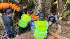
Subterranean rescue operations are bounded by structural, hydrological, and physiological limits that turn time into an exponential cost function. In the remote Longcheng district of Xaisomboun province, Laos, the entrapment of seven artisanal miners within a multi-level cave system serves as a stark baseline for analyzing subterranean crisis management. Following flash flooding initiated between May 19 and May 20, the mission has entered a critical phase where environmental friction directly reduces the mathematical probability of survival.
To evaluate the operational reality of this extraction, the problem must be decoupled into three distinct vectors: hydrological logistics, structural bottlenecks, and the biological endurance limits of the trapped personnel.
The Hydrological Equation and Ingress Blockades
The primary driver of this crisis is a rapid hydrological surge that converted an open, multi-level karst cave system into a pressurized hydraulic network. When heavy rainfall saturated the mountainous terrain of central Laos, surface runoff found immediate pathways into the cave, elevating the water table and sealing the low-clearance transit tunnels.
The mechanics of the ingress blockade can be categorized by specific operational constraints:
- Sediment and Viscosity Tipping Points: The floodwaters entering the cave are not clear; they carry heavy loads of suspended solids and mountain sediment. This creates a dual failure mechanism. First, the sediment reduces underwater visibility to absolute zero, forcing rescue divers to rely entirely on tactile navigation. Second, as water velocity drops in wider chambers, the sediment settles into low-clearance choke points. On May 24, persistent rain deposited enough silt to completely block a critical 50-centimeter gap located 100 meters into the cave, forcing teams to pivot from exploration to physical sediment excavation.
- The Volumetric Draining Deficit: Mitigating a cave flood requires the mechanical displacement of water at a rate that exceeds the natural recharge rate of the aquifer. In Xaisomboun, the physical geography dictates a structural logistics bottleneck. The cave entrance is located at the end of a steep, 4-kilometer mountainous trail inaccessible to vehicles. Every piece of equipment—including diesel generators, high-capacity water pumps, and fuel—must be carried manually up a steep incline. This weight limitation caps the total horsepower of the pumping apparatus deployed at the site, making it impossible to out-pump incoming water during active downpours.
Structural Bottlenecks and Spatial Constraints
Unlike open-water diving or structural collapse rescues, cave rescues are severely restricted by immutable geometry. The Xaisomboun cave system features a multi-tiered topology where vertical descents separate horizontal chambers. The structural constraints dictate the pace of the operation.
[Cave Entrance]
       │ (60cm Vertical Choke Point / 4-km Mountain Hike)
       ▼
[Level 1 to 3 Chambers]
       │
       ▼
[Level 4: Escape Point] ─── (Survivor swam out during surge)
       │
       ▼
[50-cm Silt Choke Point] ── (Divers reached 100m mark here)
       │ ── (Estimated 30-meter flooded gap)
       ▼
[Target Subterranean Air Pocket] (Hypothetical refuge of 7 miners)
The first physical restriction is the entrance profile. The primary access portal is a narrow, rocky fissure barely wide enough for a single technician to pass through at one time. Inside, the main transit conduit collapses to a vertical clearance of just 60 centimeters.
This geometry forces specific tactical limitations:
The narrow space eliminates the use of standard open-circuit scuba configurations. Divers cannot wear twin-cylinder configurations on their backs; instead, they must utilize side-mount configurations or push their cylinders ahead of them through the mud.
Progress requires crawling and tilting at a 45-degree angle along sharp, unmapped limestone walls. This severe friction slows the forward movement of elite divers—including veterans from the 2018 Tham Luang rescue in Thailand and international specialists from Finland—to a fraction of standard operational speeds. Currently, the diving advance is stalled roughly 100 meters into the system, with the target pocket estimated to be at least 30 meters beyond the furthest accessible point.
Subterranean Biological Endurance Function
The survival probability curve of the seven trapped individuals is governed by four interdependent environmental variables. Because an escaping survivor confirmed the existence of elevated chambers above the initial flood line, the operational hypothesis assumes the group reached a dry upper pocket. However, maintaining vital signs in a sealed karst environment depends on a strict biological countdown.
1. Thermal Degradation and Hypothermia
Subterranean air and water temperatures in flooded karst systems remain consistently low, typically hovering between 15°C and 20°C in tropical upland regions. Wet clothing combined with high relative humidity accelerates conductive and convective heat loss from the human body. Without active movement or external thermal insulation, hypothermia sets in progressively, slowing metabolic rates, impairing cognitive function, and eventually causing cardiac arrest.
2. Atmospheric Gas Composition
In a sealed subterranean pocket, the atmosphere undergoes continuous degradation. The metabolic consumption of oxygen ($O_2$) by seven adults produces a corresponding rise in carbon dioxide ($CO_2$).
The hazard progresses through predictable physiological thresholds:
As ambient $O_2$ drops from 21% toward 15%, cognitive clarity and muscular coordination degrade. Concurrently, if $CO_2$ levels accumulate past 5%, the occupants will experience hypercapnia, characterized by severe respiratory distress, physical exhaustion, and rapid loss of consciousness. The presence of decaying organic matter or micro-fissures connecting to decomposing soil layers can accelerate this atmospheric deterioration.
3. Dehydration and Toxic Inundation
While the human body can endure caloric deprivation for multiple weeks, the survival limit without hydration is approximately 3 to 7 days. Although the trapped individuals are surrounded by water, that water is highly contaminated with agricultural runoff, suspended silt, and potentially toxic heavy metals associated with local gold deposits. Consuming turbid, untreated cave water introduces a severe risk of acute bacterial gastroenteritis. The resulting diarrhea rapidly accelerates systemic dehydration, neutralizing the survival advantage of the water source.
Macroeconomic Drivers of Subterranean Risk
To fully understand the context of this extraction, the human element must be mapped to regional economic realities. The trapped individuals are not recreational spelunkers; they are local villagers engaged in informal, small-scale artisanal mining.
Laos retains a low per-capita GDP, averaging between $2,000 and $2,500 annually, with significantly lower capital baselines in rugged provinces like Xaisomboun. The presence of alluvial gold deposits in the region creates a powerful economic incentive that overrides structural safety hazards and official government prohibitions.
This economic drive intersects with a recent expansion in the domestic mining landscape. Between 2023 and 2025, the region saw the opening of nearly 200 alluvial mining operations, driven largely by foreign direct investment from China and Thailand. Although the government instituted a ban on new alluvial gold exploration permits due to severe environmental degradation, informal subsistence mining persists along unmapped geological veins. The physical entry into deep, multi-level cave networks during the transition to the monsoon season represents a calculated survival strategy against rural poverty, albeit one with a high systemic risk profile.
Tactical Reconfiguration for the Extraction Phase
As the timeline crosses the seven-day mark without direct audio or visual contact, the extraction strategy must transition from a linear dive-and-search model to an integrated, multi-vector recovery framework.
The current operational blueprint relies on deploying three coordinated efforts:
                  [SURFACE ARCHITECTURE]
                            │
       ┌────────────────────┴────────────────────┐
       ▼                                         ▼
[Hydrological Management]              [Topographical Overlays]
 - Man-portable high-head pumps          - Aerial LiDAR mapping
 - Silt-busting polymer injection        - Air shaft exploration
 - Divers clearing 50cm choke point      - Deep-earth drilling options
The first priority is the optimization of the hydrological infrastructure. Rescuers must bypass the logistical mass limit by deploying man-portable, high-head trash pumps capable of handling high solids-by-volume metrics without clogging. Simultaneously, the injection of non-toxic flocculants or polymers at the choke points can help settle the suspended sediment, restoring the critical visibility required for divers to navigate the remaining 30 meters of the flooded conduit.
The second priority requires shifting resources to surface topology. Because the interior passageways present severe geometry bottlenecks, the Association of Volunteers for Lao People and international teams must utilize aerial LiDAR and high-resolution topographic overlays to inspect the limestone karst surface above the cave coordinates. Identifying secondary air shafts or vertical sinkholes offers a non-hydraulic alternative for ingress. If a viable air shaft is located, it can be stabilized and used to drop life-support payloads—including thermal blankets, clean water, and communication links—or serve as an anchor point for a vertical drilling rig, bypassing the flooded subterranean tunnels entirely.