The magnitude 7.8 earthquake that struck off the southern coast of Mindanao on June 8, 2026, represents a definitive case study in rapid geomorphological alteration. While public discourse frequently characterizes such seismic events solely by surface destruction and casualty figures, the primary structural output of this megathrust event was a massive, instantaneous redistribution of geological mass. The sudden rupture along the Cotabato Trench altered the regional baseline geography by permanently elevating portions of the seabed by up to two meters and extending the subaerial shoreline by as much as 200 meters across the Sarangani and Davao Occidental provinces. Understanding this phenomenon requires a strict mechanics-based decompression of coseismic deformation, subduction zone dynamics, and the subsequent ecological and hydrological instabilities.
The Kinematics of Coseismic Rebound
The physical transformation of the Mindanao coastline cannot be understood through vague concepts of environmental shifting. Instead, it must be evaluated via the principles of elastic rebound theory applied to subduction interfaces. The fundamental structural driver here is the Cotabato Trench, an active oceanic trench where the Celebes Sea plate subducts eastward beneath the Philippine Mobile Belt at a high angle of convergence.
During the interseismic phase—the period between major earthquakes—the overriding plate locks against the downgoing oceanic slab due to friction. As the subducting plate continues its downward trajectory, it drags the edge of the overriding plate downward with it, storing immense elastic strain energy and causing slow, long-term land subsidence along the immediate coast.
The mechanics of the June 8 event follow a strict three-stage progression:
- Strain Accumulation: For decades, tectonic plates converge at velocities measured in millimeters per year, bending the leading edge of the overriding plate downward.
- Frictional Rupture: The accumulated shear stress eventually exceeds the static frictional resistance of the fault plane, initiating a rapid slip across a localized rupture zone.
- Coseismic Uplift: The deformed overriding plate rapidly snaps back upward and oceanward to relieve the elastic strain.
This vertical velocity component is what produced the mapped two-meter vertical displacement. The water column directly above this displacing mass was displaced simultaneously, generating the localized tsunami observed during the event, while the underlying physical rock mass remained permanently elevated above the mean sea level.
Quantifying the Spatial Realignment
The physical expression of a two-meter vertical uplift across a variable coastal topography yields a highly non-linear seaward extension of the shoreline. The common misconception is that the beach grew or that the sea retreated due to systemic water loss. In reality, the horizontal extension is entirely a function of the coastal slope geometry.
The relationship governing the horizontal shoreline extension ($E$) can be modeled using basic trigonometry where $U$ represents the vertical uplift and $\theta$ represents the angle of the nearshore coastal shelf slope:
$$E = \frac{U}{\tan(\theta)}$$
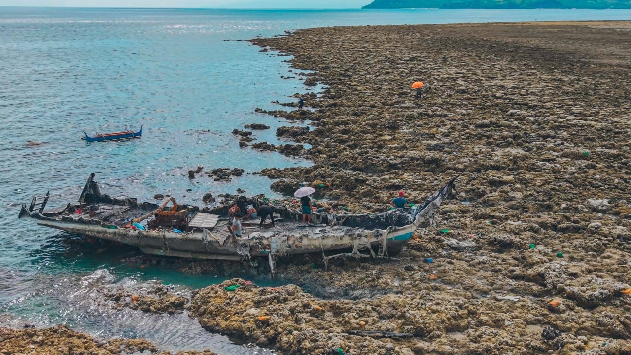
Where the nearshore topography consists of a steep bathymetric drop-off (a high value for $\theta$), a two-meter vertical uplift yields negligible horizontal shoreline advancement. Conversely, along the shallow, low-gradient reef flats and tidal shelves characteristic of parts of Sarangani and Davao Occidental, a minimal vertical displacement translates to an expansive horizontal migration of the tidal interface. This geometric variance explains why certain localized sectors witnessed a dramatic 200-meter expansion of dry land, while adjacent, steeper coastal cliffs showed no visible horizontal change.
Ecological and Hydrological Shock Waves
The permanency of coseismic coastal uplift introduces structural shocks to both biological and hydrological systems. The immediate exposure of previously deep subtidal zones to subaerial conditions has initiated an immediate ecological decay cascade.
Habitat Desiccation Dynamics
Submerged marine infrastructure, specifically shallow fringing coral reefs and seagrass beds, depends on continuous submersion to regulate temperature, salinity, and nutrient exchange. The sudden elevation of these habitats by two meters placed them entirely above the mean high-water spring tide level.
- Primary Desiccation: Complex coral matrices and seagrass communities were immediately exposed to direct solar radiation and atmospheric oxygen, initiating rapid cellular death.
- Trophic Collapse: The mortality of foundational reef builders has eliminated the primary sheltering and feeding grounds for resident organisms, including reef fishes, eels, clams, and polychaetes.
- Biogeochemical Off-Gassing: The decomposition of hundreds of tons of biomass across the newly exposed 200-meter terrestrial strip has generated localized concentrations of hydrogen sulfide and organic compounds, raising initial public health concerns regarding atmospheric toxicity.
Upstream Hydrological Recalibration
The geomorphological alteration is not confined to the marine-terrestrial boundary; it dictates a forced recalibration of inland fluvial networks. Rivers and streams discharging into the Celebes Sea base their velocity, sediment transport capacity, and channel morphology on the local base level, which is determined by sea level.
When a coastline undergoes a two-meter vertical uplift, the physical gradient between the upstream river channel and the new mouth increases sharply. This elevation differential accelerates the velocity of outgoing water, triggering a process known as knickpoint migration, where accelerated erosion moves upstream, potentially destabilizing riverbanks and undermining bridge foundations.
Furthermore, where the newly elevated coastal mass blocks historical river channels, the water is forced to execute a natural structural adjustment. The river must carve a entirely new pathway to the sea. If the newly adopted path intersects existing municipal footprints, it introduces severe, unmitigated alluvial flooding risks to communities that were previously considered safe from riverine overflow.
Long-Term Structural Engineering Constraints
The emergence of hundreds of hectares of subaerial land has prompted premature assessments regarding its utility for infrastructure expansion or agricultural resettlement. From an engineering standpoint, utilizing newly uplifted coastal land introduces critical liabilities.
The primary constraint is geological instability. Land elevated through rapid co-seismic displacement lacks the consolidated stratigraphy required for high-load foundations. The underlying materials consist of unlithified marine sediments, loose coral rubble, and saturated sand layers. These profiles are highly susceptible to secondary settlement and are prime candidates for severe liquefaction during future seismic events or intense aftershock sequences.
Historical precedent from the 2013 magnitude 7.2 Bohol earthquake demonstrates that while some coastal uplift zones remain elevated for centuries, they remain dynamic zones subject to localized post-seismic relaxation or rapid coastal erosion. The Department of Environment and Natural Resources (DENR) has rightly categorized these zones as hazardous exclusionary sectors rather than development assets. The eastern seaboard of the Philippines exhibits a localized relative sea-level rise that tracks at roughly three times the global average due to broader oceanographic trends. This means that while the land was pushed up by two meters overnight, long-term sea-level encroachment will systematically aggressively erode these unstable, unlithified coastal margins.
The optimal strategy for regional planners is a complete moratorium on civil infrastructure development within the 200-meter uplift zone. These newly emerged areas must be legally designated as structural geologic monuments and natural buffer zones. This designation serves a dual purpose: it permanently isolates human populations from a high-hazard zone prone to flash flooding, landslide-induced river blocks, and liquefaction, while allowing the exposed marine substrates to naturally weather into stable limestone buffers that can absorb future marine energy.