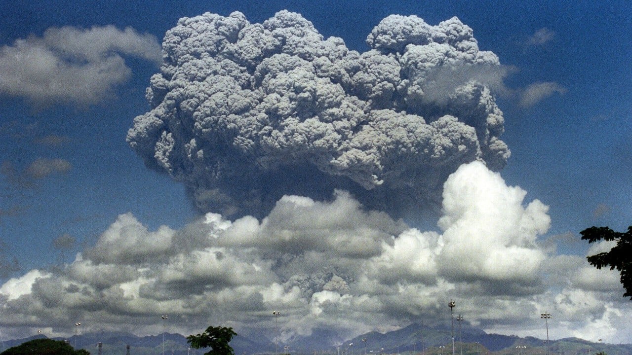
On June 15, 1991, Central Luzon went entirely dark in the middle of the day. It wasn't a standard storm. Mount Pinatubo, a volcano that had slept for five centuries, blew its top in the second-largest volcanic eruption of the twentieth century. The blast ejected more than one cubic mile of magma and hurled a suffocating blanket of ash 22 miles into the stratosphere.
If you think a volcanic eruption is just about lava, you're missing the real horror of what happened in the Philippines. The timing couldn't have been worse. Just as the volcano peaked, Typhoon Yunya slammed directly into the island of Luzon. The combination of falling volcanic ash and torrential rain created a deadly trap that caught thousands of residents and military personnel off guard. Learn more on a similar topic: this related article.
Understanding the Pinatubo disaster isn't just a history lesson. It's a case study in how planetary systems collide, how modern evacuation strategies save lives, and how a single geological event can literally cool the entire earth.
The Day the Sky Fell Wet Concrete
Most people assume the heat or the lava kills you during a volcanic eruption. With Pinatubo, the primary killer was gravity, amplified by wet ash. Additional journalism by NBC News explores comparable perspectives on this issue.
When Typhoon Yunya crossed Luzon, its driving rains mixed with the estimated seven billion tons of airborne ash. This didn't create a normal mud. It created a substance with the density of wet concrete that settled onto every roof in a 25-mile radius. Standard tropical homes, built to withstand wind and rain, stood no chance against that weight. Thousands of roofs collapsed across Angeles City, surrounding villages, and major American military installations.
Of the 847 people who lost their lives during the disaster, the vast majority died because their roofs caved in on them while they sought shelter from the storm.
The chaos wasn't limited to the ground. The ash cloud covered 125,000 square kilometers, turning morning into a 36-hour long night known locally as Black Saturday. Friction within the rushing ash column generated blinding, constant displays of volcanic lightning. It looked like the end of the world. Even hundreds of miles away in the South China Sea, ships reported being coated in grey powder, while commercial airliners flying far west of the islands choked on the drifting debris. At least 16 jets flew into the cloud, suffering $100 million in engine damage before the aviation world realized the scale of the plume.
The Tech and Trust That Saved 5,000 Lives
Pinatubo could have easily claimed tens of thousands of lives. The death toll stayed relatively low because of an aggressive, data-driven collaboration between the Philippine Institute of Volcanology and Seismology (PHIVOLCS) and the U.S. Geological Survey (USGS).
When the volcano first woke up with small steam explosions on April 2, 1991, scientists didn't waste time. They deployed seismographs and tiltmeters to measure the mountain's breathing. By May, sulfur dioxide emissions soared from 500 tons a day to over 5,000 tons. This proved fresh magma was rising fast. Then, the gas levels suddenly dropped.
To an amateur, less gas sounds like good news. To volcanologists, it was a terrifying signal. The magma's escape routes were blocked, pressure was building, and a massive explosion was inevitable.
Scientists set up three distinct evacuation circles:
- A 10-kilometer inner zone for the indigenous Aeta highlanders.
- A 10-to-20-kilometer mid-zone.
- A 20-to-40-kilometer outer zone, which engulfed Angeles City and Clark Air Base.
Getting people to leave wasn't easy. Many lowlanders didn't want to abandon their homes, businesses, and livestock. Some members of the indigenous Aeta community initially believed their god, Apo Namalyari, would protect them from harm. To convince people to flee, experts used video footage of past volcanic disasters, showing the raw power of pyroclastic flows.
It worked. More than 75,000 people evacuated before the cataclysmic June 15 blast. This proactive evacuation saved an estimated 5,000 lives and kept $250 million worth of property out of harm's way.
Operation Fiery Vigil and the End of an Era
The eruption didn't just reshape geography. It reshaped global geopolitics. Central Luzon was home to two massive American military hubs: Clark Air Base and Subic Bay Naval Station. Together, they housed over 16,000 American citizens.
As the mountain rumbled in early June, the U.S. military launched Operation Fiery Vigil. It became the largest emergency evacuation of American citizens since the fall of Saigon in 1975.
Aircraft were flown out of Clark Air Base on June 8. Thousands of personnel and their dependents packed into vehicles and drove 30 miles southwest to Subic Bay. When Pinatubo blew and the typhoon struck, Subic Bay wasn't safe either. The Navy stepped in, using an armada of ships to ferry evacuees 350 miles south to Cebu Island. From there, a massive airlift moved more than 18,000 Americans back to repatriation centers in California and Washington.
The damage to the infrastructure was terminal. Clark Air Base sat directly under the ash plume, completely buried under a heavy grey landscape. The Cold War was ending, and the cost to rebuild the base was astronomical. On July 17, 1991, the United States announced it would never reopen Clark. Decades of American military presence in that corner of Luzon ended not by a political treaty, but by volcanic fiat.
The Long-Tail Nightmare of Lahars
The eruption officially ended in September 1991, but the disaster didn't stop. The mountain left behind massive deposits of loose volcanic debris, filling valleys up to 660 feet deep.
Every rainy season for the next decade turned these valley deposits into lahars. These aren't regular mudslides. Lahars are boiling-hot, fast-moving rivers of volcanic rock and water that travel at speeds over 20 miles per hour. They can be 30 feet thick, hundreds of feet wide, and tear down everything in their path.
[Volcanic Ash on Slopes] + [Heavy Monsoon Rain] = Lahar (Dense Volcanic Mudflow)
In the years following 1991, these secondary mudflows deposited over three cubic kilometers of debris into the lowlands. They wiped out nearly every single bridge within 30 kilometers of the summit. They buried entire towns, destroyed the farms of 100,000 people, and displaced tens of thousands of families who thought they survived the worst of the volcano.
The Aeta people suffered the most. Around 20,000 indigenous highlanders were permanently displaced from their ancestral mountain lands, forced into government resettlement camps where they faced disease and a total loss of their traditional way of life.
How Pinatubo Altered Global Weather
The most staggering impact of Pinatubo wasn't local. It changed the climate of the entire planet.
The force of the eruption blasted nearly 20 million tons of sulfur dioxide straight into the stratosphere. Over the course of 22 days, this gas cloud circled the globe, reacting with water vapor to create a persistent layer of sulfuric acid aerosol. This haze acted like a giant mirror, reflecting solar radiation back into space.
As a result, global temperatures dropped by about 0.5°C (0.9°F) between 1991 and 1993. The world experienced cooler summers and disrupted weather patterns, which slowed down global sea level rise and altered ocean evaporation rates for years. Scientists studying climate change still use data from the Pinatubo eruption to model how atmospheric particles affect global temperatures.
Your Next Steps for Exploring Volcanic History
If you want to look deeper into the legacy of Pinatubo and volcanic emergency responses, don't rely on generic summaries. Check out the primary research and historical logs:
- Read the USGS Fact Sheet 113-97, titled The Cataclysmic 1991 Eruption of Mount Pinatubo, Philippines. It contains the precise geological measurements gathered during the event.
- Look up historical archives on Operation Fiery Vigil through the Air Mobility Command Museum to understand the logistics of the military evacuation.
- Review the field reports from PHIVOLCS regarding modern lahar monitoring systems to see how Central Luzon protects its towns from the volcano today.